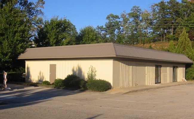
Property Record
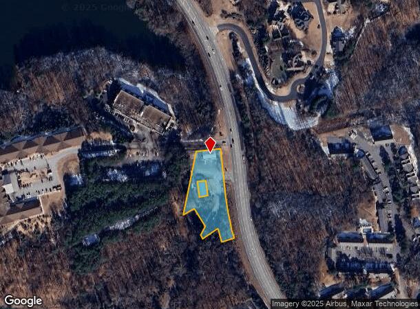
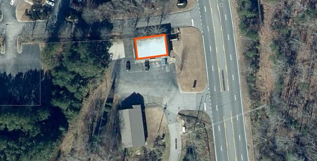
2551 Thompson Bridge Rd, Gainesville, GA 30501

NEARBY LISTINGS FOR SALE OR LEASE
Property Detail
2551 Thompson Bridge Rd
Gainesville, GA
Thompson Bridge Road
01-00100-01-002
THOMPSON BRIDGE ROAD NW
Officebuilding
Hall
X
Georgia
13139C0180G
143
2025
1.35 AC
2025
Gainesville/Hall County
000401
Atlanta
2,480 SF
DEMOGRAPHICS near 2551 Thompson Bridge Rd
1 Mile
3 Mile
5 Mile
2024 Total Population
2,673
27,579
70,000
2029 Population
2,942
30,486
77,438
Pop Growth 2024-2029
+ 10.06%
+ 10.54%
+ 10.63%
Average Age
42
41
38
2024 Total Households
1,034
11,062
25,230
HH Growth 2024-2029
+ 10.15%
+ 10.50%
+ 10.62%
Median Household Inc
$60,682
$65,257
$59,194
Avg Household Size
2.40
2.40
2.60
2024 Avg HH Vehicles
2.00
2.00
2.00
Median Home Value
$459,999
$341,541
$287,608
Median Year Built
1982
1985
1988
Nearby Places
Map Layers
Map Styles
 Street
 Aerial
- Restaurants
- Banks
- Shops
- Fitness
- Groceries
PUBLIC TRANSPORTATION
COMMUTER RAIL
DRIVE
WALK
Distance
7 min
4.0 mi
SALE & LEASE HISTORY
LISTING DATE
SALE/LEASE

Nov 02, 2022
For Lease
Nearby Properties
Address
Land Use
TOTAL SIZE
Lot Size
Zoning
Address
Land Use
TOTAL SIZE
Lot Size
Zoning
564,132 SF
48.45 AC
PUD
Address
Land Use
TOTAL SIZE
Lot Size
Zoning
66,720 SF
27.49 AC
PUD
Address
Land Use
TOTAL SIZE
Lot Size
Zoning
39,637 SF
31.55 AC
R-II
Address
Land Use
TOTAL SIZE
Lot Size
Zoning
2,038 SF
20.92 AC
R-II
Address
Land Use
TOTAL SIZE
Lot Size
Zoning
19,875 SF
19.76 AC
R-B
Address
Land Use
TOTAL SIZE
Lot Size
Zoning
163,951 SF
19.10 AC
AR-1
Address
Land Use
TOTAL SIZE
Lot Size
Zoning
56,780 SF
16.78 AC
PUD
Address
Land Use
TOTAL SIZE
Lot Size
Zoning
76,726 SF
0.42 AC
C-B
Address
Land Use
TOTAL SIZE
Lot Size
Zoning
46,795 SF
17.38 AC
PUD
Address
Land Use
TOTAL SIZE
Lot Size
Zoning
11,430 SF
38 AC
R-I
Address
Land Use
TOTAL SIZE
Lot Size
Zoning
128,531 SF
13.32 AC
R-I
Address
Land Use
TOTAL SIZE
Lot Size
Zoning
148,619 SF
30.75 AC
O-I
Address
Land Use
TOTAL SIZE
Lot Size
Zoning
54,720 SF
32.52 AC
R-II
Address
Land Use
TOTAL SIZE
Lot Size
Zoning
1,441 SF
10.46 AC
PUD
Address
Land Use
TOTAL SIZE
Lot Size
Zoning
4,032 SF
89.43 AC
R-I
Address
Land Use
TOTAL SIZE
Lot Size
Zoning
123,944 SF
13.21 AC
G-B
Address
Land Use
TOTAL SIZE
Lot Size
Zoning
113,288 SF
46.89 AC
AR-1
Address
Land Use
TOTAL SIZE
Lot Size
Zoning
1,628 SF
10.41 AC
PUD
Address
Land Use
TOTAL SIZE
Lot Size
Zoning
60,062 SF
0.51 AC
C-B
Address
Land Use
TOTAL SIZE
Lot Size
Zoning
67,383 SF
1.68 AC
C-B
Address
Land Use
TOTAL SIZE
Lot Size
Zoning
12,200 SF
0.30 AC
C-B
Address
Land Use
TOTAL SIZE
Lot Size
Zoning
16,388 SF
5.16 AC
N-B
Address
Land Use
TOTAL SIZE
Lot Size
Zoning
47,432 SF
15.80 AC
R-II
Address
Land Use
TOTAL SIZE
Lot Size
Zoning
90,044 SF
11.23 AC
PCD
Address
Land Use
TOTAL SIZE
Lot Size
Zoning
168,924 SF
0.62 AC
C-B
Address
Land Use
TOTAL SIZE
Lot Size
Zoning
6,062 SF
17.54 AC
R-I
Address
Land Use
TOTAL SIZE
Lot Size
Zoning
37,632 SF
8.52 AC
R-II
Address
Land Use
TOTAL SIZE
Lot Size
Zoning
93,869 SF
10.40 AC
PUD
Address
Land Use
TOTAL SIZE
Lot Size
Zoning
1,440 SF
10.29 AC
R-II
Address
Land Use
TOTAL SIZE
Lot Size
Zoning
118,564 SF
2.97 AC
PUD
The World's #1 Commercial Real Estate Marketplace
Connect with us
© 2025 CoStar Group
The information above has been obtained from sources believed reliable. While we do not doubt its accuracy we have not verified it and make no guarantee, warranty or representation about it. It is your responsibility to independently confirm its accuracy and completeness. Any projections, opinions, assumptions, or estimates used are for example only and do not represent the current or future performance of the property. The value of this transaction to you depends on tax and other factors which should be evaluated by your tax, financial, and legal advisors. You and your advisors should conduct a careful, independent investigation of the property to determine to your satisfaction the suitability of the property for your needs.